Day Two: Proof we were there

Never trust anything you read on the internet or receive through email. Its too easy to doctor both stories and photos. When in doubt search on Google or Yahoo because the chances are what ever the story you are looking for someone will have researched whether or not it is true already. With that said I though I might post a few "people" pictures to prove we were actually there. I don't like "people" pictures but sometimes, like on vacation, I have to take them just because.


My girlfriend near Moriskie Oko. It was early so you can see there are only a few people milling about.


Another of my girlfriend and Morskie Oko. This one is taken from Czarny Staw. You can see the start of the trail heading over Szpiglasowa Przełęcz just to the left of her elbow.


Here is one of me standing along the trail around Czarny Staw. Again you can see how simply pure the water here is.


Finally a couple shot. This is about 10m into the Rysy trail near an area where there was still snow in July.

Friday, August 31, 2007

Day Two: Morskie Oko

Day two of our Tatra trip saw us going to the most popular and crowded section of the mountains, the Dolina Rybiego Potoku and the famous Morskie Oko. Morskie Oko, which means "Sea Eye" in English, is by far the most popular tourist destination for Polish people and it is said to have been the favorite of the late Pope John Paul II. Because of its popularity the "hike" to the eye is up a paved path and, if you are especially lazy, you can even ride up in a horse drawn cart. The truly lazy also ride back down in the carts! However, those that brave the hazardous sidewalk to the lake are rewarded with views of a breathtaking lake as well as some of the most impressive climibing areas of the entire Tatras.


After the leisure two hour walk we were greated with this amazing view of the lake and surrounding peaks. The mountain pass (the dip in the middle above the trees) is the spot of the path I showed a few post ago highlighting some of the more dangerous trails.


Here is another view of the lake from the mountain lodge located along its shores. We reached the eye around 9:30 in the morning, fairly early, and there were only a few people on the beach. Czarny Staw is located in the upper valley (the saddle point to the left) and if you look close enough you can see the thirty minute trail up.


This picture was selected because of the amazing view it provides of the lake, valley, and mountain lodge. Without realizing it, however, this picture is looking in the exact opposit direction as the one above it. This photo was taken from Czarny Staw looking directly at the mountain lodge; the photo above this one was taken from the mountain lodge looking directly at Czarny Staw. Excellent. The hazardous path I was talking about above and in another post is seen to the left of this photo as a large "Z".


Once at the Czarny Staw level you can walk around a bit and that is just what we did. This path leads to the trail up Rysy, one of the highest peaks in the Tatras, but we only walked part way around. You can see from this photo that the lakes are exceptionally clean and pure. It goes without saying that the water was freaking cold, even in July!


Here is a view of both Morskie Oko and Czarny Staw. I walked up the first 10 meters of the very difficult trail to Mięguszowieckie Szczyty to get this shot. The people seen in this photo are only a fraction of the number to be found down at the mountain lodge.


After climbing down from Czarny Staw we walked around the far side of the lake to get this shot. In it is shown Niżny Źabi Szczyt (main peak in the middle). This peak along with Rysy, Mięguszowieckie Szczyty, and several others mark the border between Poland and Slovakia. Rysy can be seen in this photo; its the peak about 1/3 from the right hand side. The trail to the top is the diagonal line from the snowy area that is almost in the shade.


This range is seen from the path to Morskie Oko and is also runs along the border between the two countries. I can't figure out which it is exactly, and therefore its name, but its a nice photo anyway.

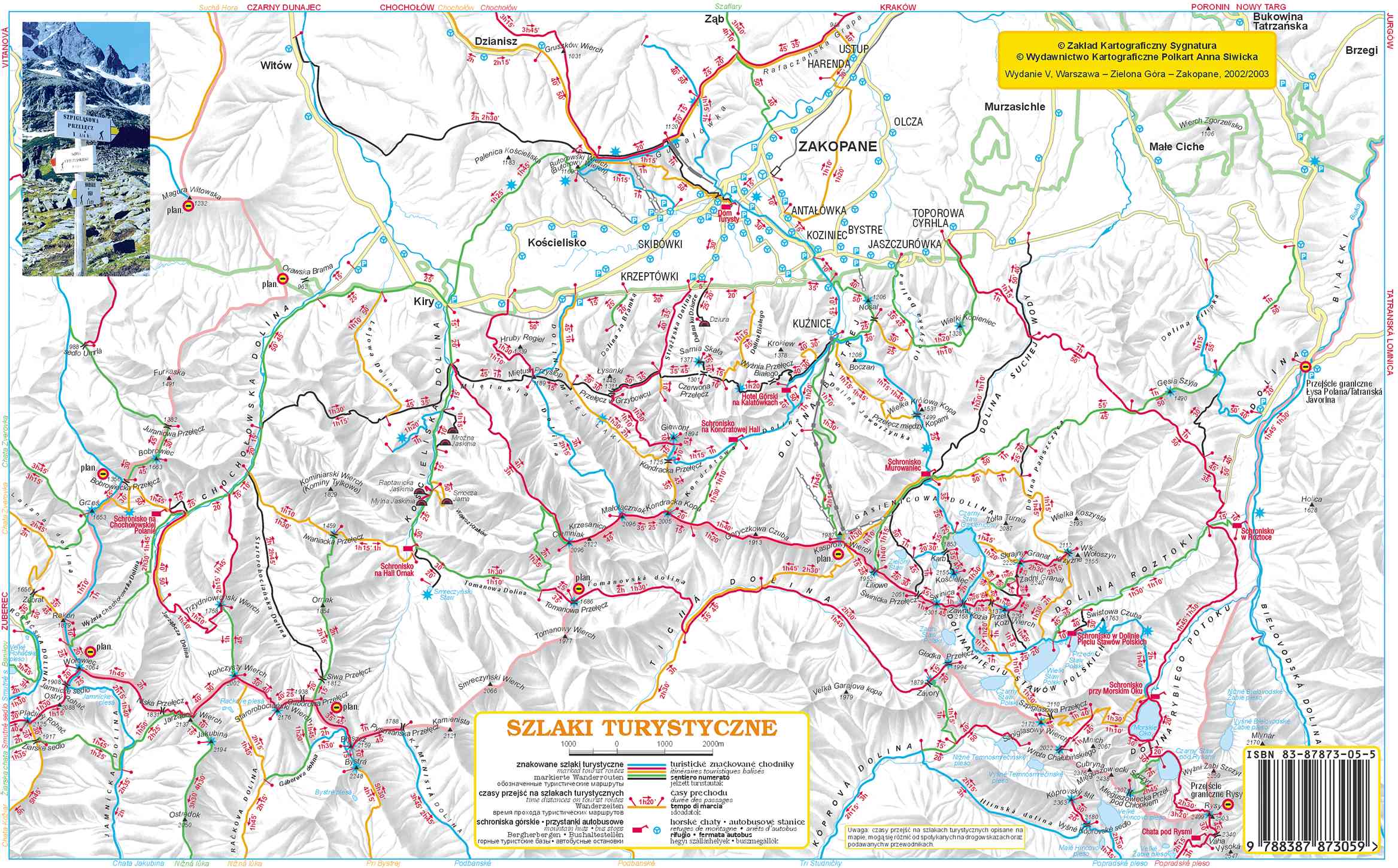
In all our trip took about 9 hours and we were both really beat after. We attempted to hike over one of the passes to the valley of the five lakes but were stopped by an impassable (for us) section. I will talk about that in another post however. Here is a map of our day two hike. Please notice the strange dead-end purple mark indicating our aborted mountain pass attempt.

Wednesday, August 29, 2007

Day One: Giewont

For our first trip we decided to attempt one of the easier peaks; Giewont. This peak is visible from Zakopane and is known for the HUGE cross on it. The cross is 15m (~45feet) tall and acts like a giant lightning rod. Not a great place to be during a thunder storm.


Anyway, we started our trip up Dolina Małej Łąki, shown above. It was very peaceful and we only saw two other people. For two hours we had shade, a nice breeze, and a gentle slope. Then, with little warning, we started our assent to Kondracka Przełęcz. This took us up about 400m (~1200ft) pretty much straight up. It was like spending an hour on a Stair Master.


On the way up we were presented with many beautiful views of both the valley below and the surrounding peaks. This photo shows a nice view of Mała Turnia.


Once on Kondracka Przełęcz (see photos from the first Tatra post - the ones with the sign) it was a short walk to Giewont. Here is a view of the peak along with the huge cross. We were unfortunatley unable to make it to the top (acrophobia) but with some practice we are confident we will make it next time.


During lunch our heart rates returned to normal and we were able to enjoy the wonderful views from the "top". In this photos you can see both our route to the bottom as well as Mały Giewont, the smaller peak of the Giewont set. This route had two yellow hazard markers; the first was no problem but the second was a bit different. While standing on a ledge about 40cm (~7inches) wide above a sheer 30m (~90ft) drop, we waited for several people to climb down a 3m (~9ft) cliff. The climb itself was not difficult but waiting on the small ledge with the rather large drop below...


Before we made the journey down, however, we snapped a few photos including this one of the path down along with the surrounding peaks. We were lucky to have absolutely wonderful weather for our entire trip which allowed for such great photos.


Like the trip up the way down presented us with several wonderful views of the mountains. Here is a view looking back up at the Giewont peaks, Mała and otherwise. If you look close at the middle peak you can see the cross.

In all our first day took us about 7 hours. Three up, three down, and another hour fooling around eating and drinking water in between. We didn't actually make the peak but we did pretty well for our first time out. Check out this map to see our route which is shown in purple. Our apartment was around the word "Krzeptówki".

Friday, August 24, 2007

The Basics


The most important thing when hiking is being prepared. And this includes a good map to help you find your way. In the Tatras (the Polish section at least) the hiking trails are all marked using a color (note: not colour) coded system. For blue trails go this way, for yellow go this way, etc. The colors do not, however, offer any information concerning the difficulty of the trail. We were unable to find a map that did too although I am sure they exist. Our simply showed a yellow hazard sign on the trail where there was danger. This could be a previous land slide area that was now safe, a trail that uses chains and requires climbing, or even a trail that consists of a sheer clif and requires a leap of faith. A wide range and not very helpful. We lost over an hour on one trail because the obstacle was too much for us and we had to turn back.


Away from the signs trails are indicated by a painted mark. They are either painted on rocks or on trees as shown here. I have heard that in winter it is difficult to see the markers painted on rocks which often results in tourists becoming lost.


An example of a trail that it might be good to know about BEFORE you attempt it is the one from Morskie Oko past Szpiglasowa Przełęcz to Dolina Pięciu Stawów Polskich. It only has three hazard signs but is it really difficult? I don't know. We were big wimps and didn't even attempt it! Next time... Can you see the trail on the picture? Can you see the people?


Here is another picture of that area. Can you see the people now?

For a basic idea of our map here is a similar map. Morskie Oko is in the bottom right corner near the ISBN barcode. The trail I am talking about is from Morskie Oko to the left. Its the yellow trail but the hazard signs are missing from this map. This photo was taken from Czarny Staw which is closer to the barcode. I will refer to this map in future posts so take a quick look now.


Thursday, August 23, 2007

Tatra Mountains


My girlfriend and I spent a wonderful week in the Polish Tatra Mountains back in July and I would like to share some of our photos. We took over 300 photos so I will unfortunately only be able to show a small portion of them. Once I am back in America I will have a large photo album with all of the better photos so hit me up if you want to see more. These photos show my girlfriend and I at different places along our hikes through the mountains. Top left and right: Kondracka Przełęcz near Giewont. Bottom left: Strążyska Dolina. Bottom right: Czarny Staw pod Rysami.

The Tatra Mountans are located in the southern area of Poland along the Slovakia-Poland border. There have been people in the area for hundreds of years but it has only been a hot Polish tourist destination for the past seventy or so. The tallest peak (on the Polish side) is only about 2500m (8200ft) which, compaired to the Alps, is not enough to draw many international tourists.

Here is a site that provides some background information about the geography of the Tatras here. Another great site is 360 Panorama. They have great 360 panoramic photos of the Tatras as well as other Polish/Eastern European places. You might have to click on the British flag to get English but it should work right away.


Tuesday, August 21, 2007

Last from CACM for now


Here are two final photos from Cambridge American Cemetery and Memorial. The first is a variation of the US Great Seal that appears on the main entrance of the Cemetery as well as on the Visitor Center (shown here). I have not been able to find any finformation about this particular version of the Great Seal. The second shows the Great Seal for the state of California. It is in the form of stained glass and is located in the chaple along with the seals for all of the other states as well.

Here is a brief description of the seal as described at netstate.com:

" Under the gaze of Minerva, the Roman goddess of wisdom, a miner works near the Sacramento River. A grizzly bear rests at her feet and ships ply the river. The Sierra Nevada mountains rise in the background. Wildlife, agriculture, natural beauty, commerce, and opportunity are all represented on California’s Great Seal."

Saturday, August 18, 2007

The missing


At the Cambridge American Cemetery and Memorial there is the Tablet of the Missing upon which the names and particulars of the 5,126 Missing in Action, lost or buried at sea, or those "Unknowns" (see picture below) whose remains could not be identified are listed. In this photo you can see the wall behind one of four statues representing the men lost. This photo shows the Airman. The other statues are of a soldier, a sailor, and a Coast Guardsman.

Across the top of the wall is a portion of the dedication by President Eisenhower from the "Golden Book" which is at St. Paul's Cathedral in London. It reads:
The Americans, whose names here appear,
were part of the price that free men
for the second time this century
have been forced to pay to defend
human liberty and rights
all who shall hereafter live in freedom
will be here reminded that to these men and their comrades
we owe a debt to be paid
with grateful remembrance of their sacrifice
and the high resolve that the cause for which they died
shall live eternally


The book is located here.

Tuesday, August 14, 2007

No mercy


Only the dead have seen the end of war


Cheshunt crash crash


One of the many stories of individual heroics during war time is the story of B24H, aircraft #42-95023. After a mid air collision with a B17 the pilot of the doomed aircraft, 2/Lt Ellis, was able to a steer the plane away from the towns of Cheshunt and Waltham Cross into a nearby field. The pilot and crew perished in the crash but no one on the ground was injured. Although some remain skeptical of the details in this incident, the towns dedicated the plaque shown here. A link to details of this crash as well as other B24 crashes and information can be found at B-24.net.

Friday, August 10, 2007

Cambridge American Cemetery and Memorial


One of the first places I visited once I moved to England was the Cambridge American Cemetery and Memorial. It is located about 10 miles West of Cambridge in the town of Madingley. It was a cold and quiet Winter day when I visited, January 6th 2005 to be exact, and I was basically alone in the cemetery. It was eerie to walk among so many headstones but it filled me with a sort of nationalistic pride to know that American soldiers helped win such a monumental victory for Western Civilization. As I stood between the rows of nearly 9000 head stones and thought of the almost 500,000 American Military dead and the 60,000,000 overall dead the enormity of World War 2 and its impact on humanity was overwhelming.

It also made me think of my friends currently serving in the US Military. It is sad that future generations of Americans will only be able to shake thier heads in disbelief about how recklessly we sent our sons, brothers, and fathers to die in the desert because of a bunch of lies.

Information about this cemetery can be found on the American Battle Mounments Comission website here. There is a PDF at the bottom of the page with excelently detailed information about the cemetery. I recommend everyone visiting Europe make it a point to visit this or other similar sites.

Two pictures of the cemetery; one showing the vast field of graves and the other the main drive of the site.

Wednesday, August 08, 2007