Showing posts with label Tatra. Show all posts

Goodbye to the Tatras


So we have reached the end of the Tatra photographs and, although I have many more photos, it is time to say goodbye until next year. As a last post I would like to show a possible future non-heights-limited version of myself. We met this guy at the base of Rysy after he had been to the top and back. "Nah, its not difficult. There are even chains at the top to make it easier." Right...

For our next series I am going to post some photos from around Warsaw. Everything from the shitty little village I live in to the metropolitan city center and beyond. Keep checking back weekly for more photos and strange and sometimes funny stories!

Sunday, September 23, 2007

Just how popular?

I wanted to add a few photographs that show just popular Morskie Oko is with Polish people. Remember that at around 9:30AM there were only 20 or so people milling about. And then, an hour later...


Not bad. This is around 11AM. After another hour, when all of the lazy people finally make it up the 2 hour walk...


I have no idea how big the area is but its safe to say that every rock had someone standing on it. In addition to all their friends, it is (I guess) sometimes necessary for people to bring furniture as well. Here was can see a nice end table, um, right next to the water. I guess it makes sense if you want to read for a bit along the shore and then take a nap. You would have some place to put your book!


Thursday, September 20, 2007

A closer look


A few photos of flowers and butterflies from the Tatras. My girlfriend realized she was interested in learning how to take photos and the two photographs above are hers.


Sunday, September 16, 2007

The look of fear

Now that we have finished the chronology of our trip I want to add a few side posts that I think you guys might find interesting. The first has to do with my overwhelming fear of falling to my death. Technically this is called Acrophobia but it is more commonly called a fear of heights. I know, I am a wimp.


While we would be walking along a trail, steep or otherwise, I would be fine. Then a narrow section with a large drop below would come along and things would get tense. This feeling occured several times but once, as we were making our way from Morskie Oko to Dolina Pięciu Stawów Polskich (Valley of Five Lakes), I couldn't overcome my fears and had to turn back. Here is a picture of the overall trail although I do not know if the "hard" section can be seen. I think it might be the large slide section seen as tan right in the middle but I am not sure.


Either way the trail at this point was only about four inches wide and was not a ledge so much as a flatter section of a large bald rock across the trail. There was not really any grip either and the span was about eight feet and the fall below was at least 40 feet. If there had been a chain to hold or something it might have been different but as it was there was no way I was going to make it. This picture shows me just after we decided to turn back: "The look of fear". Nice huh?


On the positive side we decided to walk up to Czarny Staw after we returned to Morskie Oko because we had the rest of the day to kill. So while the trip to the Valley of Five Lakes was a bust we did get to see Czarny Staw. As I said before, "next time". Here is a few of Morskie Oko as we made our way back down.

Wednesday, September 12, 2007

Day Four and Five: R&R

After two hard days on the trail and one day of cool-down we decided to take it easy and play tourist. We hit all the popular sites in town, did some shopping, and, on the last day, spent quality time at a pool.

The first place we saw on day four, mostly because it was downhill from our apartment, was the Sanktuarium Fatimskie church. The church is dedicated to "Our Lady of Fatima" which is what the Blessed Virgin Mary is known as by those who believe that she appeared to three shepherd children at Fátima, Portugal on the 13th day of six consecutive months in 1917.


In front of the church is an identical giant cross to the one on top of Giewont. The cross on Giewont is not able to be seen in this photo but would be on the background peak directly above the old guy walking on the right hand side.


The church is very devoted to John Paul II and even built several buildings/chaples as offerings for his health in the 80s because of the atempt made on his life. In addition there are several statues of the Pope, two shown here, spread across the site. The Pope later visited and consecrated the church.


After the church we made our way to the top of Gubałówka. This is your basic tourist area with plenty of souvenir stands, restaurants, and the like. There is also an Alpine Slide there as well. It is not as big as the one in Park City, Utah, but is fun none the less. Here is a photo of my girlfriend after her ride.


On a clear day the view from Gubałówka must be amzing. Unfortunately it was cloudy when we were there so the photos are not that great. Here is one of us with Giewont in the background.


After the Alpine Slides we decided to relax with some beers (shown) and then spent the rest of day four shopping in Zakopane.

The wether on day five was excellent so we decided to not bother with any more tourist stuff and headed off to find a pool. We eventually found the giant "pond" at the Hotel Kasprowy. This is a large outdoor pool that is in the form of a natural pond. It has an absolutely beautiful view of the Tatras and I am very dissapointed I did not take my camera. If any of you make it to Zakopane in summer time this pool is a nice, but somewhat expensive, way to spend a lazy day enjoying the sights. On the map of days four and five the hotel is circled.


Friday, September 07, 2007

Day Three: Mrożna Jaskinia

After the two long trips on days one and two we decided to take it easy on day three. After sleeping in and a big breakfast we headed up Dolina Kościeliska (I haven't mentioned this yet but dolina means valley in Polish - so we walked up the Kościeliska valley) to Mrożna Jaskinia. This cave is the only one in the Tatra National Parks system with electricity that allows casual tourist like us to explore it without additional equipment. This, and the easy walk to the entrance, make it a popular spot for not only tourists but also youth camps. After the light fourty minute walk to the entrance we had to wait an additional fourty minutes to get to the front of the line and gain access to the cave.


Although the wait was a bit annoying we were quickly impressed by the narrow passages and interesting feel to the cave. I thought it might suck walking single file through the cave but the organization was good enough that once inside it felt as though we were in there with only a few other people. A few areas were very tight and claustrophobic, a few were huge wide open caverns, while other areas consisted of difficult climbs up or down. It was fun as I had never been in a cave like this and would now like to try one that requires spelunking gear. Here are a few of our pictures from inside.


After the thirty minute walk through the cave you exit at a different location and are forced to walk down a huge series of stairs to the valley below. At the bottom we rested along a small stream with about 60 loud Polish kids in youth camps. It is safe to say that Polish youths are as annoying as American kids. We decided to quit the shore and walk slowly down the stream away from the kids. It is a peaceful stream that is quite beautiful at many spots. Here is one such spot.


As we slowly made out way back to the car we decided to rest again in this small forest area. This particular valley, Kościeliska, is well know for its beauty as well as a starting place for adventurous who make the several day trip along the ridge line of the Tatras. I have been told this trip, going West to East, can take anywhere from three days to seven days. There are many mountain huts/lodges along the way to take shelter in. It might be fun to do this some day but not just yet.

So, a late start followed by a relaxing walk through Dolina Kościeliska and Mrożna Jaskinia. Day three was the beginning of the end for our more active days but we are both quite pleased with what we did and saw. As before here is a map of Day Three.

Monday, September 03, 2007

Day Two: Proof we were there

Never trust anything you read on the internet or receive through email. Its too easy to doctor both stories and photos. When in doubt search on Google or Yahoo because the chances are what ever the story you are looking for someone will have researched whether or not it is true already. With that said I though I might post a few "people" pictures to prove we were actually there. I don't like "people" pictures but sometimes, like on vacation, I have to take them just because.


My girlfriend near Moriskie Oko. It was early so you can see there are only a few people milling about.


Another of my girlfriend and Morskie Oko. This one is taken from Czarny Staw. You can see the start of the trail heading over Szpiglasowa Przełęcz just to the left of her elbow.


Here is one of me standing along the trail around Czarny Staw. Again you can see how simply pure the water here is.


Finally a couple shot. This is about 10m into the Rysy trail near an area where there was still snow in July.

Friday, August 31, 2007

Day Two: Morskie Oko

Day two of our Tatra trip saw us going to the most popular and crowded section of the mountains, the Dolina Rybiego Potoku and the famous Morskie Oko. Morskie Oko, which means "Sea Eye" in English, is by far the most popular tourist destination for Polish people and it is said to have been the favorite of the late Pope John Paul II. Because of its popularity the "hike" to the eye is up a paved path and, if you are especially lazy, you can even ride up in a horse drawn cart. The truly lazy also ride back down in the carts! However, those that brave the hazardous sidewalk to the lake are rewarded with views of a breathtaking lake as well as some of the most impressive climibing areas of the entire Tatras.


After the leisure two hour walk we were greated with this amazing view of the lake and surrounding peaks. The mountain pass (the dip in the middle above the trees) is the spot of the path I showed a few post ago highlighting some of the more dangerous trails.


Here is another view of the lake from the mountain lodge located along its shores. We reached the eye around 9:30 in the morning, fairly early, and there were only a few people on the beach. Czarny Staw is located in the upper valley (the saddle point to the left) and if you look close enough you can see the thirty minute trail up.


This picture was selected because of the amazing view it provides of the lake, valley, and mountain lodge. Without realizing it, however, this picture is looking in the exact opposit direction as the one above it. This photo was taken from Czarny Staw looking directly at the mountain lodge; the photo above this one was taken from the mountain lodge looking directly at Czarny Staw. Excellent. The hazardous path I was talking about above and in another post is seen to the left of this photo as a large "Z".


Once at the Czarny Staw level you can walk around a bit and that is just what we did. This path leads to the trail up Rysy, one of the highest peaks in the Tatras, but we only walked part way around. You can see from this photo that the lakes are exceptionally clean and pure. It goes without saying that the water was freaking cold, even in July!


Here is a view of both Morskie Oko and Czarny Staw. I walked up the first 10 meters of the very difficult trail to Mięguszowieckie Szczyty to get this shot. The people seen in this photo are only a fraction of the number to be found down at the mountain lodge.


After climbing down from Czarny Staw we walked around the far side of the lake to get this shot. In it is shown Niżny Źabi Szczyt (main peak in the middle). This peak along with Rysy, Mięguszowieckie Szczyty, and several others mark the border between Poland and Slovakia. Rysy can be seen in this photo; its the peak about 1/3 from the right hand side. The trail to the top is the diagonal line from the snowy area that is almost in the shade.


This range is seen from the path to Morskie Oko and is also runs along the border between the two countries. I can't figure out which it is exactly, and therefore its name, but its a nice photo anyway.

In all our trip took about 9 hours and we were both really beat after. We attempted to hike over one of the passes to the valley of the five lakes but were stopped by an impassable (for us) section. I will talk about that in another post however. Here is a map of our day two hike. Please notice the strange dead-end purple mark indicating our aborted mountain pass attempt.

Wednesday, August 29, 2007

Day One: Giewont

For our first trip we decided to attempt one of the easier peaks; Giewont. This peak is visible from Zakopane and is known for the HUGE cross on it. The cross is 15m (~45feet) tall and acts like a giant lightning rod. Not a great place to be during a thunder storm.


Anyway, we started our trip up Dolina Małej Łąki, shown above. It was very peaceful and we only saw two other people. For two hours we had shade, a nice breeze, and a gentle slope. Then, with little warning, we started our assent to Kondracka Przełęcz. This took us up about 400m (~1200ft) pretty much straight up. It was like spending an hour on a Stair Master.


On the way up we were presented with many beautiful views of both the valley below and the surrounding peaks. This photo shows a nice view of Mała Turnia.


Once on Kondracka Przełęcz (see photos from the first Tatra post - the ones with the sign) it was a short walk to Giewont. Here is a view of the peak along with the huge cross. We were unfortunatley unable to make it to the top (acrophobia) but with some practice we are confident we will make it next time.


During lunch our heart rates returned to normal and we were able to enjoy the wonderful views from the "top". In this photos you can see both our route to the bottom as well as Mały Giewont, the smaller peak of the Giewont set. This route had two yellow hazard markers; the first was no problem but the second was a bit different. While standing on a ledge about 40cm (~7inches) wide above a sheer 30m (~90ft) drop, we waited for several people to climb down a 3m (~9ft) cliff. The climb itself was not difficult but waiting on the small ledge with the rather large drop below...


Before we made the journey down, however, we snapped a few photos including this one of the path down along with the surrounding peaks. We were lucky to have absolutely wonderful weather for our entire trip which allowed for such great photos.


Like the trip up the way down presented us with several wonderful views of the mountains. Here is a view looking back up at the Giewont peaks, Mała and otherwise. If you look close at the middle peak you can see the cross.

In all our first day took us about 7 hours. Three up, three down, and another hour fooling around eating and drinking water in between. We didn't actually make the peak but we did pretty well for our first time out. Check out this map to see our route which is shown in purple. Our apartment was around the word "Krzeptówki".

Friday, August 24, 2007

The Basics


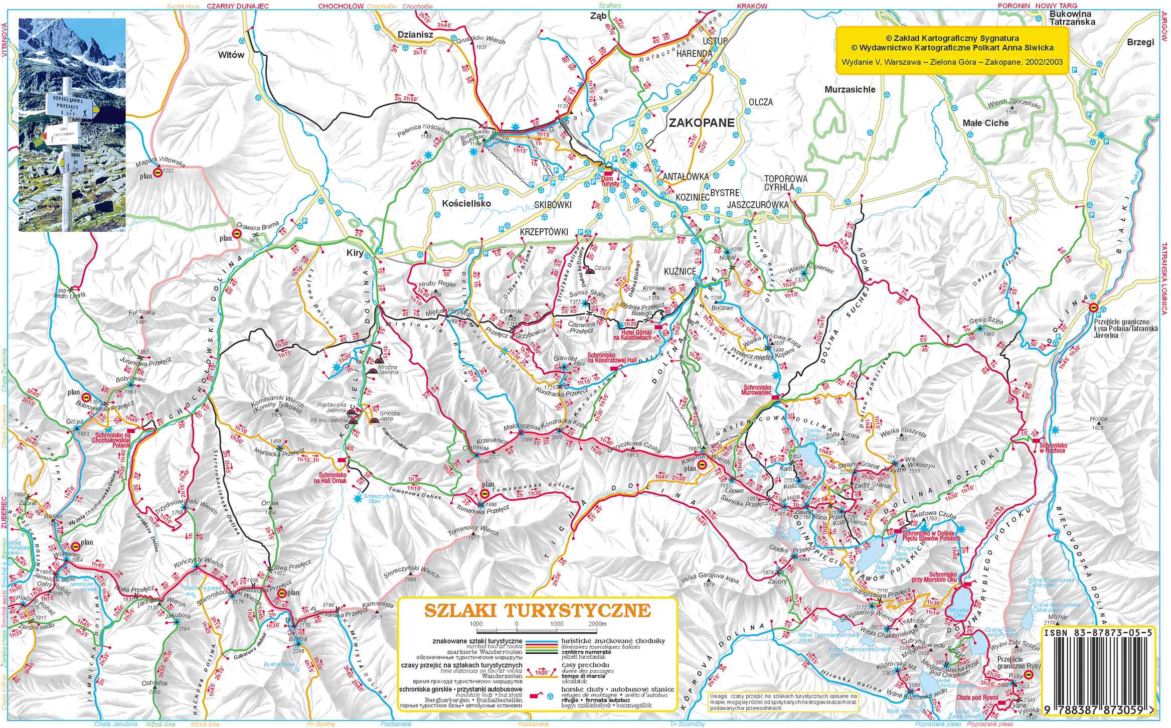
The most important thing when hiking is being prepared. And this includes a good map to help you find your way. In the Tatras (the Polish section at least) the hiking trails are all marked using a color (note: not colour) coded system. For blue trails go this way, for yellow go this way, etc. The colors do not, however, offer any information concerning the difficulty of the trail. We were unable to find a map that did too although I am sure they exist. Our simply showed a yellow hazard sign on the trail where there was danger. This could be a previous land slide area that was now safe, a trail that uses chains and requires climbing, or even a trail that consists of a sheer clif and requires a leap of faith. A wide range and not very helpful. We lost over an hour on one trail because the obstacle was too much for us and we had to turn back.


Away from the signs trails are indicated by a painted mark. They are either painted on rocks or on trees as shown here. I have heard that in winter it is difficult to see the markers painted on rocks which often results in tourists becoming lost.


An example of a trail that it might be good to know about BEFORE you attempt it is the one from Morskie Oko past Szpiglasowa Przełęcz to Dolina Pięciu Stawów Polskich. It only has three hazard signs but is it really difficult? I don't know. We were big wimps and didn't even attempt it! Next time... Can you see the trail on the picture? Can you see the people?


Here is another picture of that area. Can you see the people now?

For a basic idea of our map here is a similar map. Morskie Oko is in the bottom right corner near the ISBN barcode. The trail I am talking about is from Morskie Oko to the left. Its the yellow trail but the hazard signs are missing from this map. This photo was taken from Czarny Staw which is closer to the barcode. I will refer to this map in future posts so take a quick look now.


Thursday, August 23, 2007

Tatra Mountains


My girlfriend and I spent a wonderful week in the Polish Tatra Mountains back in July and I would like to share some of our photos. We took over 300 photos so I will unfortunately only be able to show a small portion of them. Once I am back in America I will have a large photo album with all of the better photos so hit me up if you want to see more. These photos show my girlfriend and I at different places along our hikes through the mountains. Top left and right: Kondracka Przełęcz near Giewont. Bottom left: Strążyska Dolina. Bottom right: Czarny Staw pod Rysami.

The Tatra Mountans are located in the southern area of Poland along the Slovakia-Poland border. There have been people in the area for hundreds of years but it has only been a hot Polish tourist destination for the past seventy or so. The tallest peak (on the Polish side) is only about 2500m (8200ft) which, compaired to the Alps, is not enough to draw many international tourists.

Here is a site that provides some background information about the geography of the Tatras here. Another great site is 360 Panorama. They have great 360 panoramic photos of the Tatras as well as other Polish/Eastern European places. You might have to click on the British flag to get English but it should work right away.


Tuesday, August 21, 2007